


"The territory embraced in township 3 north, range 8 east, of the government survey, was set off from Pontiac township in 1836, and organized for civil purposes as a township by itself, under the name of White Lake, said name being derived from the beautiful sheet of water which lies partly within its limits.
The lake was a favorite resort with the former occupants of the region, who despite their proverbial habits of painting and making themselves as hideous as possible, and their well known love of strife, had still many attributes which belong to a more civilized race. The copper-hued denizens of the forest had a deep admiration for the beauties of nature, and their appreciation of them is shown in the choice they made of the shores of White Lake for a camping-ground.
The waters of White Lake are clear and beautiful; the shores are high and bold on nearly all sides, in a few places, however, sloping gently back. A gravelly beach extends nearly the entire distance around it, and in several localities the drooping branches of trees almost lave their foliage in its pure waters. The shore is indented by numerous bays, and an occasional point extends outward in a long and narrow reach, lending variety to its beauties. The most picturesque feature of the lake is found in its island scenery. On the east shore a point shaped like the letter "J" extends in such a form as to nearly inclose a small semi-circular basin, and further south "Pine Point", crowded with its scattering pines and small trees, projects for some distance to the north and west. The area of the lake which lies in White Lake township is about two hundred and fifty acres. The view from the road, at the centre of section 7, looking southwest from the spot known as "Voorheis' Landing", is delightful. The lake is frequented during the summer by excursion- and picnic-parties, who come to its shores to spend a day in pleasurable pastime - fishing, rowing, sailing, etc."
From: History of O.C. Michigan - 1817-1877.
Philadelphia: L.H. Everts & Co., Press of J.B. Lippincourt & Co., 1877
White Lake is a 540-acre lake located in White Lake and Highland Townships, Oakland County Michigan. The lake was formed 10,000-14,000 years ago when the retreating glacier left a depression in the glacial drift which exposed the top of the water table. The bottom contour map shows the various irregular ridges, mounds and depressions which make up the bottom of White Lake. The lake is fed by groundwater from springs and a flow augmentation well. The lake surface elevation is 1019 feet above sea level and is an expression of the ground water table. White Lake has a single outlet which controls the legal level. The lake is located in the Huron River basin. Water from this system enters Lake Erie above Monroe, Michigan. The drainage basin for White Lake is 1253 acres. (Marsh & Borton, 1954)

Ormond Road is in the foreground. "Road to J.H. Smith's" is now Jackson Boulevard.
The White Lake Inn now sits on this site.
The first settlers arrived around White Lake in the 1820's. At that time, and for several years to follow, an Indian encampment was located on the shores of White Lake. The first settler, Harley Olmsted, came to Michigan from Monroe County, New York. Early township settlers included Joseph Voorhies, Jesse Seeley, Thomas Garner, John Garner, C.C. Wycoff, and John Rhodes.
Francis Beaumont was the owner of a land grant signed by President James Polk. His son John Beaumont was born in 1843 in a log cabin on the family farm on White Lake. (The farm today is known as Seven Harbors.) John spent most of his life on that Highland farm, other than the two years he spent in the Civil War. He was a lifetime member to the GAR (Grand Army of the Republic), a patriot, and used to tell his family that the first time he voted was for Abraham Lincoln, and that he had the ballot he voted on. The estate was registered with Centennial Farms by John's son Harry, in the Oakland County Museum in Pontiac.
A baby girl was born on a farm in Highland Township on Dec 16, 1849. The farmland had been purchased on a grant signed by the 11th president of the United States, James K. Polk. Eliza Beaumont was the youngest of Francis Beaumont's nine children. Eliza grew up on the farm bordering on White Lake, and she knew the hardships of pioneer life - of cooking meals in an open fireplace, of having to melt snow for drinking water, and of plugging up cracks in the drafty log cabin to keep the wind and snow from coming through. When she was eighteen, she married James Taylor, who was a Civil War veteran. He had a farm near her father's on the southern shore of White Lake, now a part of La Salle Gardens. Eliza Taylor died in her 111th year on May 27, 1960, the oldest resident of Michigan.
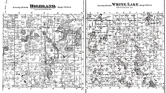
1872 Township Maps (Click to see a larger images)
The map of 1872 has George Lester owning 120 acres of land north of the Beaumont farm and bordering on both White Lake and Duck Lake.
On the 1872 map, the island was owned by P. Fisher and called Fisher Island.
It was 1886 and farming land had far more value then lake property. On September 3, 1886 a contract to drain White Lake and Duck Lake was let to Mr. Smithingill of Holly for $1,233.60, and was to be completed by November 1, 1886. A newspaper article in September of that year read: "Sportsmen and picnickers will be sorry to learn that the contract for draining Duck Lake and White lake has been let by the surveyor and the work is actively going on." Property owners all around the two lakes rejoice in the fact that the draining was not successful.
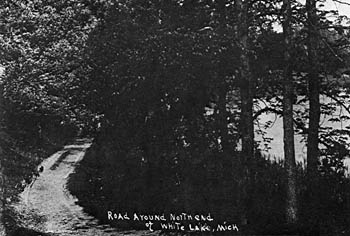
In 1899 a correspondent wrote: "A recent visit to the James Lockwood camping ground demonstrates to our mind that White Lake is bound to be a summer resort. The close proximity of these grounds to Clyde, Highland Station, and Milford, and located as they are upon the banks of beautiful White Lake, warrant the assertion that the Lockwood camping grounds will be a popular resort. Mr. Lockwood has added several more cottages and boats and now has the facilities for accommodating the public." In 1900 practically all of the people using the lake were local people and their guests. It was reported that all the cottages were rented at Lockwood's grove for the summer of 1905.
The 1908 Map shows the Lockwood camp ground which was called Grove Point Summer Resort.
The 1908 Map of White Lake shows Robert England owning 120 acres of land on the east side of White Lake, and that the portion of the land that was lakeshore was called England Beach.
The influx of vacationers from Detroit, other Michigan cities, and out-of-state people was to come later. In 1909 Highland Station reported that business had doubled during the last year, and that both afternoon trains were stopping at Highland. This was attributed to an increase in the resort business, which was growing every year for White Lake.
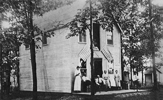
The Lakeside Store on Jackson Boulevard west of Ormond, circa 1915. Outhouses are seen to the right of the picture. The store was a popular gathering place on summer evenings, known for its good ice cream cones.
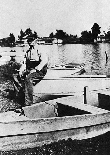
Jacob H. Smith (1849-1930), circa 1920, on his property across from the White Lake Inn
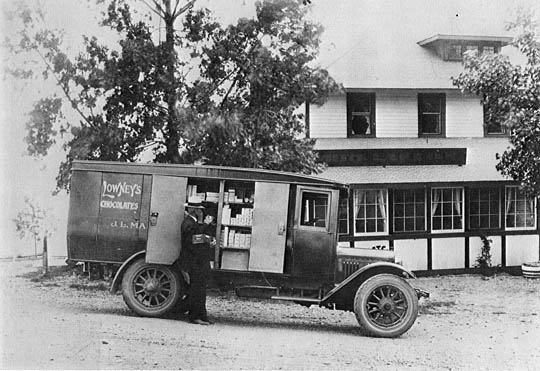
A vendor delivering to the White Lake Inn, circa 1920
On February 16, 1855 Peter Voorhies purchased the property from the U.S. Government. He in turn sold the property to Jacob Phoebe Smith in 1899, who sold it to Lewis E. Adams, who constructed the White Lake Inn in 1919. The property changed hands several times, and in 1942 Willard and Estelle Dawson recorded a Warranty Deed. The White Lake Inn was a popular local establishment.
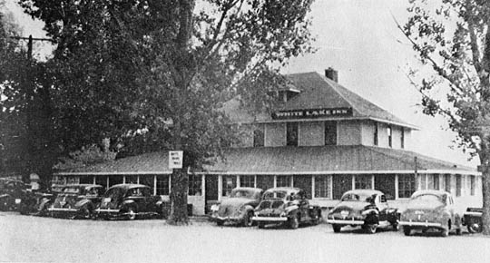
White Lake Inn - Circa 1940
In November, 1964, a fire destroyed a large portion of the kitchen, floor, and hallway leading upstairs. James and Donald Osborne, the present owners, moved their license to a building on Dixie Highway. Arlie Becker, an owner in the 1940's, repaired the building without a license and rented the building out for parties. One summer it was a teenage night club called "Mr. Lucky's". Becker was issued a new license in the fall of 1971. After changing hands several more times, it was purchased on December 17, 1982 by Mario and Jacqueline Gougeon. Mario was much loved in the White Lake community, and died in March, 2007, at the age of 64. The White Lake Inn is presently owned and operated by Paul and Elizabeth Caldwell.
On May 22, 1942 Willard and Estelle Dawson recorded a Warranty Deed that included Fisher's Island and renamed it Dawson's Island

The WLCL was started by Arleigh Hess in February 1961, for the purpose of preventing a causeway fill project from the mainland to the western point of Dawson Island. This attempted project was started without the approval of either State, County, or Township Zoning Laws, or other required regulations, and was a direct infringement on riparian water rights. Without the intervention of the Citizens League, this would have been a very undesirable division of the lake, by dividing the North and South areas with a solid causeway. Fortunately a permanent injunction was obtained against the project after five years of court litigation.
Highland Township Historical Society
"Our Highland Heritage: Sesquicentennial History of Highland Township 1835-1985"
Published By: The Highland Sesquicentennial Committee, 1986
Historical Photos of White Lake
"In Remembrance"
Published by: White Lake Township, Oakland County, Michigan 1990
Researched & written by Lynn and Connie Ross
Updated by Bob Parrett